Why report the weather and its impacts?
Our GeoSphere weather stations accurately measure properties of the atmosphere such as pressure, temperature, humidity, and other weather characteristics. However, we cannot directly measure weather impacts on the ground like storm damage, flooding, mudslides, or other significant weather phenomena and their dangerous effects such as thunderstorms, tornadoes, or ice.
In order to provide this relevant information for our forecasting team, we need reliable reports about the impact of weather on the ground - known as "impact."
By receiving this information, GeoSphere Austria can even improve disseminated forecasts and warnings for the public in real-time.
Using the web app www.wettermelden.at, you can also report any non-extreme weather and inform the GeoSphere Weather Forecaster whether their prediction for your location and time is accurate.
This is how it is done:
Before using the web app wettermelden.at, please always ensure that your mobile device's internet access and location services are enabled.
Upon opening the web app wettermelden.at in your web browser, you will encounter a brief splash screen featuring our logo, followed by the acceptance of the Terms and Conditions (AGB) and the Privacy Policy.
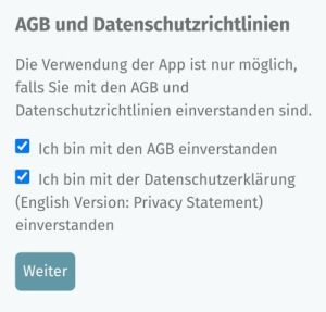
Chart:
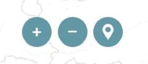
In the next step, a map will open displaying the current weather reports from the last three hours.
You can use the localization button (bottom left) on this map to verify if your device has been accurately located.
Furthermore, there are buttons available for zooming in and out on the map. On mobile devices, you can also use the typical two-finger pinch gesture for zooming, just like you would normally.
Current Weather Warn Status:
When there is an active GeoSphere Austria weather warning, an additional button will appear next to the above-mentioned buttons to display the weather warning status.


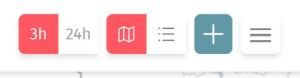
Function bar:
At the top right corner of the map, in a separate bar, additional functions are available (from left to right):
- Selection buttons for displaying reports from the last 3 hours or the last 24 hours
- When choosing the 24 hours interval, the reports within the selected map domain can also be played as a movie in chronological order
- When choosing the 24 hours interval, the reports within the selected map domain can also be played as a movie in chronological order
- Selection buttons for displaying reports in the form of a map or as a list - for both time periods, 3 or 24 hours
- Selection of reporting parameters using the PLUS button
- Menu-Button
Selection of reporting parameters, PLUS button:
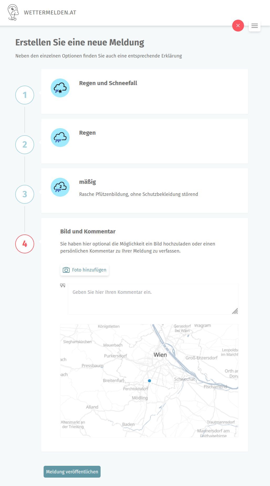
Step (1): Selecting the parameter class (e.g., Precipitation, Rain and Snowfall)
Step (2): Choosing the specific parameter (e.g., Rain)
Step (3): If applicable, selecting the parameter intensity
Step (4): Optionally take a photo, write a comment, then publish/submit the report
Menu functions:
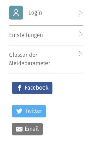
- Login:
- Registration, login function, user account management
- Settings:
- Language selection
- Glossary of reporting parameters:
- Detailed description of reporting parameters, background information, tips
- Share-Buttons
- Please select the respective share button, the link to your current report will be displayed
Important! Please follow these instructions when reporting the weather and its impacts:
- First, the most important rule:
In cases of extreme weather or other high-impact weather events, leave the danger area as quickly as possible! Report tornadoes, avalanches, mudslides, wildfires, and other dangerous phenomena from a safe distance or only (briefly) after the danger has passed. - What to use for reporting weather and impacts?
If possible, report weather and impacts ideally from outdoors, use a mobile phone or tablet, or report from protected indoor spaces (house or vehicle), e.g. with open windows. - When to report?
Weather and impact reports using wettermelden.at are real-time reports! Observations about events that occurred hours, days, or even longer ago should be added to appropriate databases like ESSL ESWD (eswd.eu) when possible, or communicated via email to wettermelden@geosphere.at. Damage parameters like avalanches, mud slides, lightning or tornado damage and similar, initially dangerous parameters may be reported at a later moment, immediately after the event. However, the described impact shall still be identifiable without any doubt. - Please don't forget!
Activate internet connection for your mobile device, enable location services - please allow the highest accuracy: e.g., satellite, mobile towers, Wi-Fi hotspots, and Bluetooth. Activate the web browser. Recommended are the latest versions of Firefox, Chrome or Vivaldi. Also, regularly clear the browser cache or perform a page reload. - Please don't forget!
Before reporting, make sure that the internet connection is working and your location has been accurately captured. If needed, press the "Location" button, to center your location on the map. Otherwise, there's a risk that an important report with valuable visual material might not be submitted at the end. - Selection if reporting parameters:
Always report the most significant weather or the strongest weather impact first, preferably with a photo. If needed, include a brief description in the notes. If there are multiple relevant reporting parameters, prioritize them hierarchically, starting with the currently strongest impact. If any uncertainties or questions occur, please refer to the glossary for more information:
https://trustedspotter.eu/en/reporting-parameters - Reports with photos:
A picture is worth a thousand words, even when reporting the weather! For measurements (e.g., hailstones, snow depth), include a commonly recognizable object for comparison or, if available, a centimeter ruler or a wettermelden.at plastic card in the photo. When reporting cloud cover, show at least 80% of the sky and a representative portion of the landscape below. In the case of broken cloudiness, capture the area with the most representative cloud cover. If possible, please add the geographical direction in the notes (this is also valid for parameters like avalanche, wildfire, mudslide, or similar damage reports). - Submitting the report:
A simple parameter report with a text description will be transmitted within a few seconds. For reports with photos (mobile phones can generate large image files), the transmission time may last longer, depending on your available internet connection. In such cases, please keep the browser, location services, and internet connection enabled. Due to poor connection, a photo in a report might also be transmitted at a much later time. When reporting via a desktop computer, an accurate location detection is often not possible – therefore, reporting with mobile devices is recommended as best practice.
- We recommend registration and login, in order to establish contact via email with eyewitnesses for subsequent investigations of extreme weather and damages. If desired, we would also like to share information about relevant events and news updates.
- Providing feedback to wettermelden(at)geosphere.at helps us in making the wettermelden.at reporting web-app user-friendly.
Thank you very much for your numerous weather reports!